Showing posts with label India International Affairs. Show all posts

Thursday, September 25, 2014

Modi's China gamble and Japan's secure friendship

When Modi ascended to power there were doubts about his diplomatic ability to gauge our neighbors who share boundaries with us and with other countries whose investment can tremendously help India. In the past few months his visit to Bhutan, Nepal, and Japan clearly demonstrated his diplomatic and business acumen of dealing with various East Asian countries. Modi's Japan tour is extraordinarily historic because no Indian Prime Minister has been able to extract such concrete investments in one single visit. 

Back in 1993 when former PM Narasimha Rao coined "Look East" policy term it was for Indian diplomacy to look east of India to countries such as China, Japan, ASEAN - (includes Brunei, Cambodia, Indonesia, Laos, Malaysia, Myanmar, the Philippines, Singapore, Thailand and Vietnam). Subsequent governments irrespective of parties contributed to this policy. At the beginning of 2000, former PM Vajpayee dedicated a lot of his diplomatic strength to make America a long standing ally of India in addition to engaging East Asian countries. His achievement was to change the definition of Indo-US ties forever. However, political, diplomatic and security compulsions led to this direction. The current PM Mr. Modi is leading this policy again of Look East but purely for economic gains. This is the first time an Indian PM is trying so hard to get China and Japan together to invest in India in very specific sectors.

Even though his tours of Nepal and Bhutan were significant for India an enormous excitement was in store for his Japan tour. The tour resulted in Japan investing close to 35 billion dollars in very specific sectors like High Speed Railways to give financial, operational and technical support. Unlike the World Bank loan which can be siphoned off easily without achieving the objective for which the loan was taken Japan will not give away hard cash. It is going to invest over 5 years and will monitor how India performs on speedy clearances and expedition of processes to ease business in India. Japan will participate in helping "Clean Ganga", "Develop Smart cities" and "Metro projects in Ahmedabad", "set up Industrial parks in the two countries", "make Varanasi like Kyoto"


The key achievement was to sign up agreements specific to these projects to be implemented in a time bound manner. I hope that the agreement translates into a reality everyone would love to see.

Apart from the photo ops and speeches made by Modi it was clear that he needed to act on this investment in a transparent manner. He has decided to set up a special team to look into the way these funds are utilized and will have a member from Japan as well. This is good as we hope that the investment is sincerely utilized to realize the election promise and the dream of India getting the bullet train. The time of completion may be 10 years but it is important to get it started.

Besides Japan also decided to sell US-2 amphibian aircraft something India needs since it carries the strength of 21 firefighting helicopters. US2 will significantly enhance Indian Navy's capabilities. For more information on the abilities read here. It is no mean achievement that Japan lifted sanctions on India with respect to sell and transfer military equipment. After World War II this is the first time Japan has done so with India. One of the most important reasons why Modi was able to extract this from Japan is because Japanese PM Abe and Modi share a personal rapport and friendship of many years.

If Japan's tour was picture perfect, Chinese President Xi's visit to India was that of a big gamble. In my previous articles I had already articulated the reasons for India's defeat of 1961 war, the cause and solution of the disputes in the Ladakh and Arunachal region. Modi knew that just like Japan, Chinese investment in India and their expertise will be of great significance. He played this gamble in a near perfect manner until the intrusion in Ladakh region became the stumbling block.

Let's understand the role of China in the Asia Pacific Region in a larger context. There are 2 hard facts to consider:

1) The control of South China Sea for decades has been a bone of contention amongst several countries like Indonesia, Vietnam, Singapore, Malacca Straits, Cambodia, Thailand and many more. 
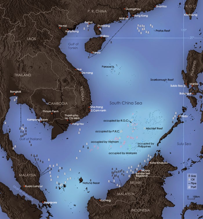
(image courtesy: Wikipedia)

China has for ages dominated the control of this sea. In order to balance this domination US allied with Japan and together they form the other end of the control. However, in recent times China has begun to get in touch with all these countries giving them economic and financial aid thereby getting their support. With the US beginning to lose its grip it began to ally with India and Japan to balance the control. In this context since 2011 Indian diplomats began steps to secure friendship with countries such as Bangladesh, Vietnam etc. The "Look East" policy that was active in 1993 under Narasimha Rao and then under Vajpayee till 2003 suddenly lost momentum and again in 2011 gained slow speed under Manmohan Singh. Modi is accelerating this policy with targeted investments so that there is a win-win situation. South China Sea is known for huge oil reserves and all countries want to control it. With China having territorial disputes with almost everyone in the region has always upped the ante. China's arch enemy is Japan and both cannot stand each other.

In this context, recently India signed agreements to provide loan and sophisticated boats to Vietnam against China's territorial aggressions in return for getting oil supply from the waters around Vietnam. The Chinese categorically warned of consequences if India extracts oil from Vietnam.

2) String of Pearl strategy by China:  When China began to rise in 2001 it began this policy of involving all of India's neighbors to form a string so that upon necessity it can prepare for attack on India. For this it began to develop friendships with Nepal flooding its market with goods and helping it in financial aid. It then began to deepen its friendship with Pakistan to develop Gwadar port to the west of Gujarat, controlling ports in Bangladesh and putting pressure on Bhutan to support China in every way. Besides all these ventures China also began developing Tibet such that within an hour through roads and high speed railways can reach Indian borders if a situation arises. The UPA Government was least interested in acting upon these steps. Only in the last few years of UPA II the former PM Manmohan Singh began to take steps to mend friendships with Bangladesh.

Modi wanted to change the situation to make China an economic partner and go beyond just boundary disputes. Keeping the boundary issues aside he wanted to involve China to invest with a strong economic agenda. When he was Gujarat CM he visited China several times and often in his speeches he talked about China as the real competitor to India. When Chinese President Xi came to India the rumor was that investment would be to the tune of 100 billion dollars - thrice the amount Japan agreed to invest. It was a huge gain if China had invested this amount. However, it reduced to 20 billion dollars, which is less than Japan's investment. What triggered this?

Like Modi, Xi is considered reform oriented Chinese President. An investment to the tune of 100 billion would have benefited China as well. It looks like there was a hidden twist to this whole story. The Chinese, exactly hours before the meeting of Modi and Xi, infiltrated into Chumar region of Ladakh. The number was 1000. This is the highest number of soldiers entering the territory post 1962 war. This whole incident shadowed the event Modi had organized.

On one side Modi achieved a lot when agreements were signed to make Pune and Ahmedabad export and manufacturing hubs, train Railway officials to increase the speed of Bangalore-Mysore-Chennai train, rejuvenating Railway stations, setting up a Railway university, giving enhanced access to Indian agricultural and pharma products in China, and opening up a new route to Manas Sarovar through Sikkim.


On the other side he had to talk tough to ask Xi to withdraw his troops. The tough negotiations by Modi finally led to the withdrawl of the troops. However, things did not stop here. Two days after this meeting troops again entered the territory. This time the number was just 50. Since this is a mystery that will hardly be revealed, this article explains 3 possible reasons as to why the Chinese intruded right at this moment - a) The People liberation Army (PLA) that is controlled by the Chinese Government is not under Xi's control b) Xi knew this intrusion and was done intentionally c) Xi wanted PLA to do its work and he wanted to do his. So, one wing aggressively pursuing border issues and the other economically winning deals with India. 

In my personal view the third reason is most probable since Chinese history is well know to all countries in South China Sea. China is probably the only country yet to have so many territorial disputes with everyone in its neighborhood. India has no options but to constantly monitor the situation and rise economically and strengthen its infrastructure in these regions.

Since Modi's ascent he seems to be planning to break the very trap China has set up. With India cozying up to Japan and the recent steps taken by his Government to engage Vietnam and Bangladesh to corner China this game of Chinese checkers is getting very interesting. China was quite naturally baffled and decided to intrude into Indian territory to increase the scale of provocation.

Such diplomatic games by China is hard to play with. With a single party and a single focused agenda Chinese government, economy and defense is way ahead of India by about 50 years, With changing political equations and central governments India lacks a consistent tough leadership. As long as Modi is going to rule India there will be tough moves by his government in every way possible.

At this point the country's economy is very important and the investments from China and Japan would play a critical role in realizing many projects which we do not have expertise in. Together this is the biggest investment India can dream of getting in to achieve its most complex goals.

Tuesday, March 25, 2014

Settling the cause of India's Pearl Harbor (1962 Indo-China War)

No other dispute in the world is as long, more complex and more controversial than that of the India-China border. The 1962 Indo China war was fought in the age of pre-internet, pre-social media, and pre-television. Radio and newspapers were the only source of information. Recently, some of the pages of the inquiry committee report of the war were leaked out. Post this leakage it's high time for settling the cause and many blunders committed during and before the war that continues to impact our diplomatic and political relationship with China till date. There has never been a public debate going into the cause, effects and solution to the problem.

China has always had expansionist mindset and it has exhibited this over centuries and more so in the early 1940 and 1950's. It is Nehru who never understood this despite many of his ministers, particularly, Sardar Patel warning him several times. I had explained the cause and solution of the border dispute clearly in two part series on my own blog 5 years ago.

The two articles above are very lengthy and I did a great deal of research to get into the root cause and find out who is right - India or China over its claims. If one gets scared at the sheer length of the article here's the conclusion. My conclusion below may provoke you to read the above articles again and again.

Solution to the Aksai Chin area: Split the Aksai Chin area into 2 parts and let India and China have it equally. This is because Aksai Chin belongs to no one based on historical records and currently this area is with China. China will not cede it and India won't give up its claim on the entire area.

Solution to Arunachal Pradesh Region: The whole area of Arunachal Pradesh except TAWANG region belongs to India. Currently, India has TAWANG that belongs to China. India won't give up and China won't stop pursuing it.

The 1962 war was the most humiliating war India ever faced and fought. India lost so badly that it took years to recover the army's morale. The war saw a patriotic wave across the country to an extent never seen before. Everyone was scared that China might penetrate deep into the Indian territory. Till date no government has ever made an attempt to declassify the exact cause of the war and the only inquiry committee report (Henderson-Bhagat report) has never been made public. The report doesn't go into explaining why the dispute started, why Tibet's voice was not even heard by China and why Tibet's annexation was unacceptable to India since it was military inquiry report. According to sources in the Indian Defense Ministry there were 3 copies of this report - two with the Government and third with Neville.  

Neville Maxwell, the journalist at that time had access to a copy of this document which he used as a basis of his book India's China war (Source). Neville's book according to several readers is more an explanation or analysis of the report and not the actual report. The book does go into the origins of the conflict. The book for the first time pin pointed Nehru for many misadventures. The problem with the book though is that it is pro-China in many ways and anti-India. One cannot take this source as an unbiased account. 

The actual report's pages were made available on Neveille Maxwell website and then several magazines such as Outlook magazine added them on Mar 18th 2014.(Source). Although the book has been in publication for quite sometime now, the report itself was made public on his website http://www.nevillemaxwell.com/ (no longer available now). 

There are parts of this report which are truly chilling and nerve raising. In the below paragraphs I have made an attempt to explain this in a brief, but clear cut manner. The report has 3 volumes and only the first volume has been leaked. Some pages of the report have been deliberately deleted. We don't know how many more generations or decades it would take to know this complete report. However, the first volume itself speaks volumes about the military blunders that continue to haunt India. 

Lt. General Henderson and Bhagat in 1962 wrote the inquiry report that went into the details of how India lost the war and what political and military decisions were taken during and before the war. 

Henderson-Bhagat Report squarely blames India for the war and puts the onus on Indian political and military leadership. The report clearly blames "Forward Policy" in Nov 1961 (the actual war started on Oct 20th 1962 and ended in a month) when it was set in motion by Nehru. The policy, according to the report, provoked Chinese to attack in a full blown scale. This policy's aim was to put troops on the border who could go deep into the areas bordering China so that Chinese will not think of claiming any territory of India as theirs. The assumption to go into this adventure was that Chinese will not retaliate and that we are capable of fighting the Chinese. 

Image courtesy: (Link)


The report highlights on military failures more than lack of political sagacity. Based on CIA report (source)we know that both Nehru and Defence Minister V.K. Menon never agreed with the estimates given by the military General B.M. Kaul and Intelligence Bureau Chief Mullick who asserted that Indian military was better prepared to deal both in the Eastern and Northern sectors. V.K. Menon blindly trusted the military and then blinded Nehru into going forward with sending troops to the border. The war significantly highlights one thing - A country's head like that of India's must not depend upon one source to take decisions in matters of defense and border disputes.

The report (Source) also explains how Lt.Gen Kaul had deep political influences and scarce regard to military hierarchy and neglect of assessing the real lack of preparation. His election itself as the Military Head of the operations in the North East was politically motivated since he was a distant relative of the then Prime Minister Nehru. He was a failure in several operations before this and yet he was appointed for the operations of the North East. North East was more difficult to fight (mainly because of temperature and terrain) and required at least 12,000 troops more than the force in Ladakh and required air force deployment. It could be one of these reasons that the Govt may have been hiding the report since it can hit the morale of the Indian Army and also the fact that Kaul was appointed because of Nehru's influence would be brought to the forefront. However, fact is a fact and hard truth cannot be hidden just because it is harsh.


Indian Army was not prepared for high altitude battle. It was used to fight on the plains with Pakistan. Lack of equipment and training to fight Chinese soldiers caused India dearly.

It was China that backtracked from its position in Arunachal Pradesh otherwise it would have conquered both north and eastern parts of India. We have to thank China for both destroying and saving the day. Their attack destroyed India and their withdrawal saved India. If that was not the case West Bengal would have been part of China since the attack could have spread so deep into the heart of India.

                                    
(Image courtesy: Hindustan Times, Calibre)

If anyone is interested in reading this report or Claude Arpi's (French journalist living in India and is considered one of the experts in Indo-Tibet-China issues) interpretation of Neville's book it is here or even Arun Shouries' book - Self Deception: India's China policies

My own take is that following political and diplomatic blunders Nehru committed with regards to China: 
  • He refused formally to discuss border issues with China despite having the opportunity several times between 1950-1954, especially after China conquered Tibet. Even when China did not respond to his oral announcement in Indian Parliament he took their silence as admission of border India claimed. Never until 1958 did it occur to Nehru that a country that is in the process of formalizing its borders (post independence) get written confirmations from China. Long before his formal letter to China time he had asked formal maps to be published indicating the Mc Mohan line and Aksai Chin part of India. As a reply to 1958 letter, Chinese rejected Mc.Mohan Line.
  • Sending Indian officials in Tawang and allow them to take care of the affairs was wrong as it was part of China.
  • The biggest opportunity was when India and China signed Panchsheel agreement and Nehru accepting claims of China over Tibet. When this was accepted all the boundary agreements that Tibet signed also was indirectly accepted by India. It was a golden opportunity to settle all border issues at that time. Had they been settled we would not have reached the position we are in right now.
  • Nehru must have given up Aksai Chin in lieu of China giving up its claims on Arunachal (Source) right in the initial stages.
  • When Nehru accepted Tibet as part of China there was no need to welcome Dalai Lama. The smart move would have been to leave the matter to China. If Nehru had not accepted so then giving refuge to Dalai Lama was not a mistake at all.
  • Blindly trusting his defense minister V.K. Menon's assessment of things without having a sharp understanding of the ground reality.
  • Ignoring Sardar Patel's written letter to be cautious of China when it invaded Tibet and reassess border posts and military strengths. (The letter is published in Makers of India's Foriegn Policy: From RajaRamMohan Roy to Yashant Sinha by J.N. Dikshit)
  • Nehru supporting for UN seat For China amidst all this.


Relying on multiple sources of information coupled with sharp understanding of the enemy is a must. Indira Gandhi and Vajpayee had both these qualities and they exhibited them in 1971 and 1999 wars with Pakistan respectively. While Indira used all the might to defeat Pakistan with a great sense of smart thinking, Vajpayee used might and diplomacy to bring Pakistan to its knees. These two wars were examples of exemplary leadership by and far, despite flaws in the operations of the two wars. Nehru lacked what both these leaders exhibited. The underestimation and overconfidence led to the most expensive and humiliating war at the hands of China.

This war has taught one lesson in matters of geographic neighbors. Never underestimate the country whom you consider as a threat, never provoke it until you are prepared with the onslaught and have a firm written document as evidence in any matters, specifically related to borders and defense.  If Nehru exhibited all these 3 qualities he would have never led India on this dangerous path.

Nehru's blunder is so deep and profound that over the years it has made it harder for any party that rules India to go back on what Nehru accepted as the true borders It is politically suicidal for any party to give away any Aksai Chin.

It's high time this issue is laid to rest and the public debate and awareness created so that everyone is aware of the geo-political reality of 1962 and its effect on the coming generations. Let's hope whoever forms the next government in May 2014 gets a chance to settle this piece of history.

Some of the good articles in this matter can also be read here:

Sunday, November 29, 2009

A decade: White House and 2 Indian PM's and 3 US Presidents

LAVISH Parties at White House for India:

Keeping politics and diplomacy aside (as to what we gained from this and what we should from this), have a look at the pictures when White House threw lavish parties for 2 Indian Prime Ministers - thrice in a single decade from 2000-2010 - to ATAL BIHARI VAJPAYEE and MANMOHAN SINGH.


WHEN VAJPAYEE DID NAMASTE WHEN HE GOT A STANDING OVATION IN WHITE HOUSE FROM THE ENTIRE CONGRESS - A Proud moment indeed!! This reception was not received by any Indian PM during the last 60 years as it happened in Sept, 2000.

The large presence of its members despite the fact that many were busy campaigning for elections in 2000.


VAJPAYEE became the 2nd member in the White House to sit down and address the entire Congress (owing to his knee problem) after Franklin . D. Roosevelt

A 20 minute address (click here for the speech) and the entire audience was clapping. Later, a lavish party by Bill Clinton.


A RECORD 700+ members attended the party - largest ever state dinner hosted by Clinton in his 10 years of Presidency just to honor Vajpayee (Indian head of the state).

The dinner included Darjeeling tea, smoked poussin, chilled green pea and cilantro soup, marble potatoes, wild copper river salmon, red kuri squash and rice, bean ragout, Swiss chard custard, garlic-chanterelle emulsion, young greens and herb salad, heirloom tomatoes, dry aged cheese blossom and 25-year-old sherry dressing. Followed by mango and banner lotus, litchis and raspberry sauce, "a majestic tiger's delight," honey almond squares and chocolate coconut bars


Obama said in his speech
(as taken from New York times and Washington Post) -

On behalf of Michelle and myself, welcome to the White House. Aapka Swagat Hai. (Applause.) Many of you were here when I was honored to become the first President to help celebrate Diwali -- the Festival of Lights. (Applause.) Some of you were here for the first White House celebration of the birth of the founder of Sikhism -- Guru Nanak. (Applause.)


Let me add also some pictures of the era when relations between India and US were full of suspicion and mistrust.


These above pics were in 1949 with Henry. S. Truman.with Kennedy and also seen is Indira.
This picture was in 1966 (above) with Lyndon. B. Johnson

This was in 1971 with Nixon (above)The last 2 were with Reagan in 1982. Also, seen is Sonia Gandhi on the extreme right.

Of course, strategically, for US, India is an important partner in South Asia to check the growing hegemony of China. And, it is in India's interest as to how it can take forward its relations from being neutral to inclining towards both US and Russia equally.

Monday, October 19, 2009

Special Series - Indo China border Dispute - II


As promised earlier, here is the second in the series of articles that discusses the Indo China Border dispute. The first part discussed about Aksai Chin - The northern border problem with China. This article talks about the Eastern border issue - Arunachal Pradesh (formerly known as North East Frontier Agency - NEFA).

THIS AGAIN WILL BE A VISUAL JOURNEY TRAVERSING THROUGH THE MIGHTY HIMALAYAS


Where is Arunachal?
In the map below is the eastern most state of India - Arunachal(marked in red), bordering Bhutan on one end and Burma on the other.

This end of the dispute is as complex as the western one.

let's go back in time

------------------1826---------------------------------------
The first Burmese war and Great Britain got Assam as per Treaty of Yandaboo. The map below shows the eastern end of Indian boundaries at this time. The Ahoms - who were ruling that region came under British rule. You can see in the map, there was no Arunachal in the picture yet. The British for the first time called areas north of Assam as North East Frontier Tract(NEFT- called by this time till Nehru renamed as NEFA).

Later, the British agen Jenkins discovered that the western end of NEFA known as Tawang (now part of India) was ruled by a king/raja and was feudatory of Tibet.

------------------1872---------------------------------------
Keen to delineate borders, the British signed an agreement with Tibet agreeing that Tawang was Tibet's and it was a bilateral agreement. Note: TIBET COULD SIGN THIS AND WAS DEEMED LEGAL. Borne this point in mind because this will serve as an evidence for the later part of the flow.
------------------1873---------------------------------------
Britain passed Bengal Eastern Frontier Regulation by which they created an Inner Line - purely for administrative purposes and Outer Line that marked the official boundary of India. Basically, Britian did not want to deal with the tribes who were staying beyond Inner line and strict instructions were given to officials not to cross this border.
------------------1904---------------------------------------
The dawn of 20th century brought Britain and Russia into the great game of ASIA. At this time, China and Tibet which existed as neighbors became areas of conflict for the 2 powers. Britain used to always consider that in order to check Russian influence or attack on India, it is necessary to make Tibet come under Britain i.e. a protectorate or sub-ordinate.

With this intention, Colonel Younghusband set on an expedition to conquer Tibet. China claims (till today) that Tibet neglected its advice else Britian would not have conquered Tibet. However, Tibetans don't agree. Younghusband without facing any resistance conquered Tibet and signed a treaty with it. Note: China didn't object to this nor questioned Tibet's independence.
------------------1906---------------------------------------
Britain and China sign a bilateral treaty confirming 1904 treaty and declaring Chinese suzeraintiy over Tibet. TIBET's SIGNATURE/ACCEPTANCE was not taken.
According to the treaty, 1904 treaty was cancelled and it was agreed that Britian will not annex Tibet and China would not allow any foreign interference in Tibet's foreign affairs or administration.

Could China do this? Without getting the consent of Tibet, how could China decide this? For centuries, Tibet was treated as an independent state. And Tibet never sent any approval or signature or seal to China allowing it to control it. This is confirmed by the letter sent by Tibetan government to Mc Mohan (British general) in 1914. Pasted below is excerpt from that letter (taken from "History of Modern Tibet" by Goldstein)

------------------1907---------------------------------------
Russia sign treaty with Britain agreeing to the fact that any issue of Tibet would have to be discussed only through China. This was done to ensure neither Russia nor Britian would influence Tibet.

First of all, 1907 was an extension of 1906. If 1906 itself has no validity because Tibet was not consulted how could this treaty be legitimate? China till today claims 1907 treaty as the basis on which Tibet could not be declared independent and hence could not sign any treaty with anyone without its consent.

------------------1908---------------------------------------
An Indian map is published showing Tawang as a part of Tibet and Indian border extended from bhtuan to baroi River (32 miles) eastward and the whole of NEFA. Observe the map and see TIBET is named as a different territory and not as a province of China. The Outer line was the boundary and till now China never claimed this area nor ever occupied(Refer to map on wiki on sino-Indian War).

Repeatedly, the British officers tried to cross Outer line despite the warnings got from London.
------------------1909---------------------------------------
The situation in Tibet has been best described by Swedish explorer Sven Hedin -(wiki on History of Tibet)

Currently, Tibet is in the cramp-like hands of China´s government. The Chinese realize that if they leave Tibet for the Europeans, it will end its isolation in the East. That is why the Chinese prevent those who wish to enter Tibet. Dala Lama in is currently also in the hands of the Chinese Government"..."Mongols are fanatics. They adore Dala Lama and obey him blindly. If he tomorrow ordering them go to war against the Chinese, if he urges them to a bloody revolution, will all like one man follow him as their ruler. China's government, which fear the Mongols, hooks on to Dala Lama."..."There is calm in Tibet. No fermentation of any kind is perceptible."(translated from Swedish) Sven Hedin had as a European in parts of his travels in Tibet been forced to camouflage himself to a Tibetan shepherd and he also visited the 9th Panchen Lama

------------------1910---------------------------------------
Chinese for the first time cross NEFA and post flags around Walong (eastern Arunachal). Walong is the eastern most town in India and is where the bloodiest battle took place in 1962.

For the first time in centuries, China sent troops to Tibet to capture. All the goodwill that existed ceased now (as narrated in The Cambridge History of Tibet). This clearly indicated that China had not direct control over Tibet till then.

------------------1911---------------------------------------
The British General Major Hamilton led an expedition trying to cross Outer Line was killed by Abhor tribes in NEFA. The British Government wanted to avenge the murder and hence started an expedition. As they proceeded they saw Chinese markers at Walong and placed British markers (flag) there.

Now, simultaneously, Chinese Xinhai Revolution - that ended Ching/Qing dynasty rule - erupted in China and China weakened. Its influence over Tibet, Assam etc, all weakened making several provinces independent.
------------------1912---------------------------------------

China for the first time became REPUBLIC OF CHINA. The new king sent troops to annex Tibet.

For the time, Tibetans felt they were bretrayed, cheated by the Chinese. Now, the 13th Dalai Lama along with all Tibetan soldiers threw the Chinese out and proclaimed independence. Even Mongolia at that time was an independent province.

The sending of troops was against the previous king Sun Yat-sen orders who stated that "All non-han (non-chinese) provinces would be free to join China or if not be independent". This was backtracked by the new king Yuan-shik-hai who proclaimed

in January 1912: "The foundation of the state lies in the people's power to incorporate the areas inhabited by the Hans, Manchus, Mongolians, Huis and Tibetans into one country and to unite the Han, Manchu, Mongolian, Hui and Tibetan nationalities into one nation. That is called the national unification." (As taken from Chinese embassy website).
------------------1913---------------------------------------
In Jan 1913, Tibet under the 13th Dalai Lama passed the proclamation of independence which stated amongst many things that

"Relationship between China and Tibet had been that of patron and priest and had not been based on the subordination of one to the other. We are a small, religious and independent nation."
This was sealed and signed and distributed to every office in Tibet and to every resident of Tibet. Tibet also signed a mutual agreement with Mongolia. The text can be found here or here

The signing of this raised the suspicion in the eyes of the British that Russia might be influencing Tibet (because of Russian presence in the treaty). Thus, The British Government began to now involve Tibet with China over boundary issue and most importantly to ensure formally that China becomes suzerain of Tibet. This was Britain's game plan to check Russian influence.

1st meeting - Oct 13, 1913 - Shimla conference called in and Tibet accepts, China rejects to come but forced to come under 1907 treaty. Tibet sends a letter to the British Govt about the fact that it is still independent.

On October 30, 1913, China presented its “counter-proposals”. Its seventh point read: “The frontier boundary between China Proper and Tibet is now roughly indicated in the accompanying map.” That line ran far to the north of Tawang

2nd meeting - Nov 18, 1913 - Inner and Outer tibet was drawn and maps given to China and Tibet. China outrightly rejected it.

3rd meeting - Maps are exchanged between Tibet and China for consulation. Tibet's opinion was expected and Chinese too.

------------------1914 - Shima -Trouble began---------------------------------------

In the 4th meeting on Feb 17, 1914 -

Mc Mohan presents a draft to the Chinese and Tibetan representatives Ivan Chen and Lonchen Shatra respectively. For the first time, the correct borders of Outer and Inner Tibet are mentioned. Inner Tibet constituted Qinghai, Ganshu, Sichuan and Yunnan while Outer tibet consitute the present Tibet Autonomous Region. Inner Tibet was to be completely under Chinese while Outer Tibet would come under Chinese suzerainity but would be autonomous. (i.e Foreign policy, defence would be under the Chinese and everything else independent). There was a blue line demarcating Inner and Outer Tibet while RED LINE became the boundary of entire Tibet. The RED LINE ON THE EAST CAME TO BE LATER KNOWN AS MC MOHAN LINE.

March 11 -
Britain's governor general Mc Mohan formally gives the draft after approval from Britain Govt in London.
March 24-25th
Tibet agrees and Lonchen Shatra sent in a written response agreeing to it -

"As it was feared that there might be friction in future, unless the boundary between Tibet and India is clearly defined, I submitted the map, which you sent to me in February last, to the Tibetan government in Lhasa and I accordingly agreed to the boundary as marked in red in the two copies of the maps signed by you, subject to the conditions mentioned in your letter dated March 24, sent to me through Mr. Bell. I have signed and sealed the two copies of the maps. I have kept one copy here and return herewith the other. Sent on the 29th day of the 1st month of the Wood-Tiger year (March 25, 1914) by Lonchen Shatra, the Tibetan Plenipotentiary"

On April 3, 1914, China presented a five-point proposal (The McMahon Line and After, Parshotam Mehra; page 216; a masterly work). There was no reference to the border with India.

A telegram of April 20, 1914, from the Waichiapu (the Chinese Foreign Office) to Ivan Chen (intercepted by the British) mentioned seven points “on which we will never give in”. Again, the same omission of the external boundary. Its telegram of April 25 hinted that except for the internal boundary the rest was acceptable

APRIL 25, 1914 - China’s Memorandum of April 25, 1914, handed to the British Ambassador also ignored Tibet’s (external) boundary with India.


APRIL 27, 1914 - TROUBLESOME DAY

On this day, all 3 representatives put their initials. Ivan Chen was not too keen but put his initials. Tibet and Britain had no issues. Remember, INITIALS and NOT SIGNATURE. If initials are put, then that particular country's seal must be there for the initials to be valid. However, this was a draft and the initials were put without seals of the respective governments. Hence, the deal was invalid. Chinese and Tibetans reply was waited.

During the same time, China formally issued the Constitution declaring Tibet as one of those which will be unified and brought into Chinese Republic.

MAY 1, 1914 - The President of China sent a Secretary to meet the British Ambassador Sir John Jordan on May 1, 1914. He said after and a propos disavowal of Ivan Chen’s initialling that “the question of boundary was the only article not generally acceptable”.

MAY 11, 1914 - The President objected to “the inclusion in Outer Tibet of Chiamdo and of complete portion of Kokonor territory”. A memo of May 11, 1914, proposed further negotiations.

JUNE 13, 1914 - A Memorandum of June 13, 1914, with a map annexed, centred again on the Inner-Outer Tibet boundary.

JUNE 29, 1914 - So did another of June 29, 1914. D.P. Choudhury points out that the line drawn in the map of June 13 “lay far away from the north-east frontier of India” (The North-East Frontier of India 1865-1914; page 157).

JULY 3, 1914

When China never responded and rejected the proposal, India signed a bilateral treaty with Tibet and finalized the boundaries. The boundaries included NEFA (not Tawang) as part of India. The initials and the seal of the govt was taken from both parties. Further,

Now, China even today says 1907 treaty and states without Chinese approval the treaty between Tibet and India is invalid. So, now any reader must question - Why didnt Tibet signature/intials taken when Tibet was to be declared a suzerain of China? Secondly, Tibet declared independence. There was no formal agreement anytime between Tibet and China to prove China controlled Tibet and hence when Tibet declared itself independent did not require Chinese ratification.

The complete agreement is here. Article 9 mentions BLUE AND RED LINE. Articles 2, 3 and 4 clearly indicate that Tibet accepts Outer and Inner Tibet partition and that China should not send any troops to Outer Tibet nor attempt to convert Tibet into a Chinese province. The Treaty cancelled 1893, 1906 treaties.

Tibet was fully legitamately independent when it signed the treaty. Note in the map below - attached to the Shimla conference even during April meeting when initials were put by all 3 parties. Observe the BLUE LINE AND RED LINE.

Note: In the map, NEFA is a part of India, but not TAWANG.


Further developments post 1914:

C. U. Atchison's Collection of Treaties was published later indicating that the treaty was not binding as it was incompatible with 1907 agreement with China.

------------------1921---------------------------------------
Britain and Russia sign another treaty cancelled 1907 agreement.
------------------1935---------------------------------------
Olaf Core (British officer) decides to publish Mc Mohan Line map officially as it was a binding agreement.
------------------1936---------------------------------------
Britain finds out that Tawang which is being controlled by Tibet (quite naturally). In 1938, Britian occupies Tawang and Tibet protested.

------------------1937---------------------------------------

It is to be noted that TAWANG is an illegal occupation of INDIA.

An official map is published by Survey of India and this was the map India published in 1947 too.

SUMMARY:

TIBET was independent enough to sign a treaty with India. And therefore Tibet that gave up NEFA to India is India's. So, no question of dispute over Arunachal except TAWANG. Se La PASS (picture below) is the last point before Tawang where a bloody battle took place in 1962.


Also, for all the above reasons mentioned, also read what International Jurists concluded about status of Tibet. they concluded that TIBET WAS INDEPENDENT between 1913- 49. It had every qualification to be declared as an Independent nation until China forcibly occupied it and signed an agreement with Tibet in 1951.

Why did China sign formally in 1951 if all the while it treated Tibet as its part?

This article stops here. The next and the last series will cover events post 1947 that led to the war.


Sunday, October 4, 2009

How prepared is India along China border?

For the last two weeks or so, Google maps, particularly, google earth, showed Arunachal Pradesh as a part of China. This was shocking. It showed it as not part of India. When Indian govt questioned, google rectified and now shows Aksai chin as disputed border in addition to Arunachal. Now, why should chinese version show up in Google maps and not the Indian version? This is THE SECOND TIME GOOGLE HAS DONE THIS BLUNDER AND IT CAN'T BE A MISTAKE...Earlier, in 2000 it did the same and then the NDA govt asked Google to quickly rectify it and so it did.


Version before Google accepted apology:
Version after google accepted the goof-up:

How can a private company like google do it twice? Any country's borders are a very sensitive issue and maps published serve a great deal of information and they should be free of such blunders.

It was very funny and embarrassing when Congress spokesperson said on NDTV's Big Fight-"I dont think the Govt is ignorant about this and would have conveyed it to the concerned people". He is not even informed of it despite the fact he works in the Govt. This is the height of ignorance. And why is the govt wanting to say that these border talks must go on. Is it serving any purpose? Is govt doing enough to solve the problem or just do the meetings? The spokesperson also said - "This must go on" and when asked why aren't 60 years enough he remarked - "They must go on"

Look at what China is doing? The picture below explains clearly(Courtesy: Telegraph).

China has well gone inside LAC - Line of Actual Control because it doesn't recognize this. The fact is Arunachal Pradesh is a part of India and there is no doubt about it. But if China is so much interested in claiming that India is the agressor then why can't it build infrastructure within LAC? Why should it violate LAC? Is China not the agressor?

India continues to neglect Arunachal and yet there are not motorable roads. If a war emerges, China would take minutes to deploy its troops while India would take days. This brings us back to 1962 war situation. Let's see what PM Manmohan Singh promised (for the first time in 60 years and I am happy, but not satisfied till completed)

Target: 2013
Things to execute:

1)1500 km Trans-Arunachal Highway running through the middle of the state - The Trans Arunachal Highway will start from Tawang on the Sino-Indian border and pass through Seppa, Sagalee, Hoj, Ziro, Daporizo, Aalo, Pasighat, Roing, Khongsa and Changlang with a link with Saikhowaghat in Assam
2) Rs.156 crore rail link connecting Itanagar (capital) to Harbuti in Assam
3)3000 MW Dibang project for electrcity (forget dams, let's consider roads first)

Of these, the best part is Border Roads Organization is incharge of most of the roads. They have been doing a good job despite extreme weather - the same extreme weather which made the Chinese withdraw in 1962. Below is the picture of a road(LOHIT bridge over Parasuram river) inaugurated in 2006 which connects China and it has changed the lives of people in that area and their earnings have never been so good in the last 50 years.

The impact of this single road: more than 300 shops from 30, with many of them selling luxury goods. A population of about 100,000 has 5,000 cellphones and schools. A journalist from The HINDU newspaper further reports -
There are professional coaching institutes, automated teller machines (ATMs), Internet cafes and many restaurants.

"Subsistence agriculture has been replaced by orange and apple orchards and cardamom plantations. There is electricity round the clock at Dirak, where one enters the district from Assam, and all the way beyond Walong, until the border with Tibet 280 km away. The long road that connects sparsely populated villages is always busy with taxis, trucks, buses and motorcycles plying up and down. The road is being improved with several concrete bridges. And along the river many mini hydroelectric projects are coming up."


There are 8 strategic roads along the border which are critical and 4 of them are complete - All by Border Roads Organization (BRO). The PM has declared the project as "The Special Accelerated Road Development Programme for North-East (SARDP-NE) " - divided into two phases: The first phase involving 1,300 km of roads primarily in the North-East State to be completed by this year-end and the second phase involved 5,700 km with the 2013 deadline.

In addition, there are various roads under construction in HP, Uttarakhand, sikkim and J&K.

India has to build roads, secure those conflicting points. It is not enough that we strengthen our navy, army and air force. We have to build roads along the border. There are no people like the Chinese when it comes to strategy and planning. They carefully plan, silently execute and loudly speak only after preparation. It is this tactical planning that always ensured China is ahead of India in every aspect. The Chinese have built 6 lane highways in Tibetian border and connected Lhasa with Bejing through a high speed link.

As far as Congress govt is concerned, it was only Narasimha Rao who tactfully followed the policy of Look East by which he started contacting other countries in East Asia who are not friendly with China to ensure diplocatic pressure on China remained always. On the other a significant breakthrough was acheived when Vajpayee visited China. This meeting settled the Sikkim and Tibet issue once for all. For almost 55 years, China claimed Sikkim and theirs, but Vajpayee's dilpomacy ensured Sikkim be accepted as India's. However, Chinese as shrewd as no one can be, backtracked a year ago on claiming Sikkim too. Now, they stopped Sikkim and restarted the claim of Arunachal.

What is needed: Speedy completion of roads and enhancing air fields along Ladakh border (already many are opened last year)